Preparing for a long road trip? Or going to hike a mountain trail?
It doesn’t matter whether you’re an absolute beginner or an expert in navigation—the best hiking apps are useful for everyone.
After all, online maps never become outdated, digital compasses will not fail you, and hike messengers are great for finding new friends and discussing the most challenging or beautiful trails.
To help you out, Hike&Cycle has gathered the most useful paid and free hiking apps you’ll want to get!
Also, Jarrimber created an infographic that features apps for true nature lovers, so feel free to check out these 8 best nature apps!
Many of the apps are available on Apple and Android, so everyone will be able to download them.
We’ve divided this article into several categories so that you can find the necessary app immediately.

Hiking map apps
Maps are the best partners in any adventure, no matter how far you plan to go.
Technology allows you to get trail maps on an iPhone or Android so that you’ll always feel confident about where you’re going.
Detailed maps and GPS functions of these apps will allow you to track your route with precision, note your location in real time, and get accurate directions. This way, you can confidently navigate unfamiliar trails, stay on your path, and minimize the risk of getting lost.
Many hiking map apps also allow you to download material for offline use. This feature is especially helpful when you venture into remote locations with no signal.
We’ve investigated the most popular GPS tracker apps that adventurers have used this year, and we’ve built a new list of maps you can download.
1. Maps 3D Pro


Source: App Store
This is a great app for every adventurer. Whether you’re a cyclist, snowboarder, or hiker, this app will satisfy all your needs.
With this GPS map app, you can record trails and refer to them offline. This is a great function that is necessary for safe outdoor adventures anywhere.
Unique feature: With Maps 3D Pro, you’ll see the surroundings in all three dimensions.
iOS 3.99$
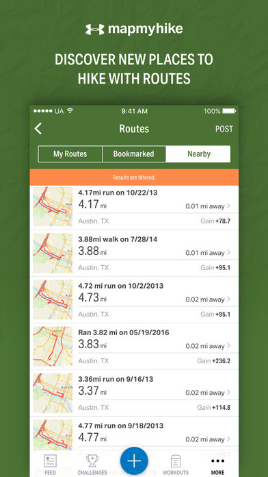
2.Map My Hike

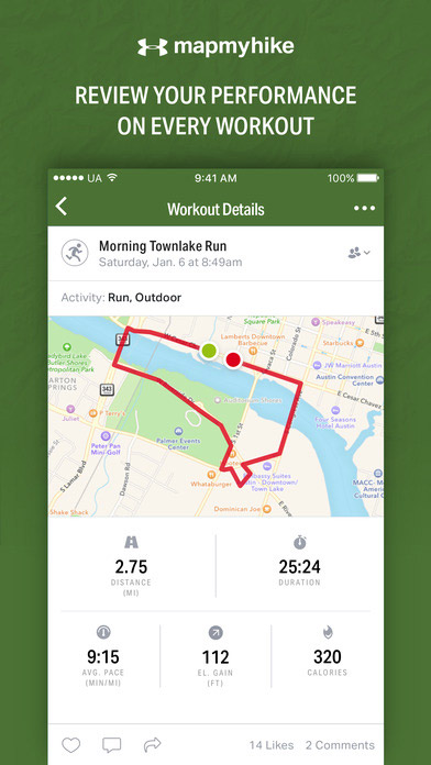


Source: iTunes
This interesting GPS mapping software will help you to travel safely and track your route. The distance you take is displayed on the map, so you’ll never get lost.
Moreover, you can see the routes your friends have taken, making it the perfect way to stay motivated and have some friendly competition. Actually, this hike tracking app is also great at inspiring you—it gives you achievements for completing various tasks.
Unique feature: This trail making app has a Routes function to help you find new hiking trails around you.
Android Free
3. ViewRanger Trails & Maps


This is a nice variant to track hiking routes on your smartphone or Apple Watch. ViewRanger allows users to find their path even offline.
Since you can share your real-time location with your friends or family members, outdoor navigation becomes easy and safe.
Upd: ViewRanger has merged with Outdooractive!
OutdoorActive provides the same satellite map layer found in ViewRanger together with the ordinary outdoor map. You can always transition to the satellite layer with a simple two-tap action. In addition to this, OutdoorActive offers new features such as weather updates and extra options for sharing routes and photos. The only drawback is its reliance on signal. On the plus side, there’s an added function to download specific map sections for offline use.
You can now download the new version below.
Unique feature: Identify peaks, rivers, and lakes using your smartphone’s camera and the Skyline function.
4. Cairn


Source: App Store
Cairn will save your route and show it offline. You can find the actual distance for thousands of trails in the US and Great Britain.
Cairn not only helps you find a hiking trail — it’s also about safety.
- You establish the expected completion time of your chosen route.
- If you don’t make it on time, the app informs the contacts you have listed.
This app also lets your contacts track your location in real time. The system of notifications helps you tell loved ones that you’re fine.
Unique feature: Use this free app to measure the time and distance of your hike without draining the battery. This is especially helpful for long trips.
iOS Free
5. All Trails


All Trails is one of the best route apps. It’s a great choice for beginners.
Wondering why?
Because it not only shows thousands of trails (actually, the All Trails hiking app has more than 50,000 routes) it also helps you choose one.
In this mapping app, you can find real hikers’ reviews of mountain, canyon, or wooded trails. The reviews always include coordinates, characteristics, and photos.
Unique feature: Can’t choose from the 50,000 routes available? It’s no surprise. Filter them by difficulty, length, rating, and activity types.
6. Gaia


Source: App Store
Gaia is the Greek goddess often called Mother Nature.
These downloadable GPS maps also act like Mother Nature! They show you every trail in your country. There are three types of maps:
- Topo
- Road
- Satellite
For countries like the USA and Canada, government offline topo maps are available.
Also, you can synchronize the apps’ maps and routes on all of your devices so you’ll never lose your saved trails and photos.
Unique feature: Gaia has worldwide maps, not only for the US and Canada. That means you can take it with you wherever you go!
7. Topo Maps+


Source: App Store
This is another GPS app for iPhone with a wide range of functions. Download the map and use it offline to avoid getting lost.
Topo Maps+ is regarded as one of the top GPS apps for iPhone thanks to its regularly updated maps of the US, Canada, and New Zealand. You can also print any of your routes just in case your device dies.
Unique feature: If you’re a hiking fan, you can use tags to organize all of your trails with this route map application
iOS Free
Hiking navigation apps
Tracking apps are real treasures for any adventurer. To feel safe during your trip, download at least a couple of outdoor navigation apps.
In this section, we want to introduce the best GPS navigation apps for Android and iOS.
With these apps, you’ll know how to:
- Find the right peak using your smartphone camera with the help of augmented reality (AR) technology. You can use your smartphone’s camera to identify mountains as well as other visible landmarks. Simply point your camera towards a particular geographical feature, and the app will overlay basic information about it on the screen.
- Navigate by the stars. Some hiking navigation apps have celestial navigation capabilities, which allow you to use the stars to find directions. These apps utilize your device’s gyroscope and compass to determine your location in relation to the stars. Then, it selects a target celestial body and guides you in the right direction. This function will come in handy when traditional navigation tools are unavailable.
- Estimate the attitude and position of stars with the naked eye. Hiking navigation apps with astronomy features go beyond simple navigation—they can also assist you in estimating stars’ position with your naked eye. These apps provide precise information about the stars visible at your location. Once you learn to recognize specific stars and their positions, you can gain insight into where you are and where to go.
The most fantastic thing about these apps is that you can use GPS without the internet connection, leaving you no chance to get lost.
8. Spyglass


Source:App Store
One of the top adventures apps, Spyglass allows you to navigate with the help of a compass and gyrocompass. This app uses your GPS location to build the right path.
With its help, you can do everything:
- Navigate by the sun, moon, and stars
- Use a compass with your map
- Know the distance and altitude you’re at plus approximate time
- Use dozens of coordinate systems and modes
Unique feature: Use the built-in star guide to navigate by the night sky map and find the nearest trail.
iOS $3.99
9. Theodolite


Source: App Store
We’re happy to introduce you to an innovative app for navigation. Theodolite has all the tools you need to find hiking trails fast: a navigation calculator, an inclinometer, a compass, and many others.
Theodolite is essential to take with you on any adventure. This outdoor navigation app is especially useful for skiing, yachting, and kayaking. You can also use the built-in monocular with two modes: 2x and 4x zoom.
Unique feature: If you want to share your location, just take a screenshot and send it by email with all the indicators on it.
iOS $5.99
10. PeakVisor


Source: App Store
Do you often try to google “mountain climbing near me” but fail because of a slow internet connection?
If so, we have a great mountain peak app for you.
PeakVisor has an enormous database of mountains with information about peaks all around the world.
Its main function is its 3D mountain panorama. Just point your camera at the horizon to get the names and elevations of all the surrounding peaks.
Unique feature: In addition to GPS navigation, this app has a Sun Trail function. You will always know how to place a compass.
iOS $3.99
11. PeakFinder


Source: App Store
This is another useful tool to find mountain trails. It can distinguish more than 300,000 peak names.
With PeakFinder, you can easily explore any mountain within a 300-kilometer range. For better navigation, the app has a list of tools including a compass and motion sensors.
Unique feature: Use the “Show Me” function of this mountaineering app to get visible peaks.
12. Star Chart


Source: App Store
Used to navigating by the stars? Star Chart will help you find your path on even the darkest nights.
In the last versions of this app, the database contains more than 120,000 stars. You can use finger gestures to zoom into any object — like a star, planet, or constellation.
Star Chart has no trouble with the dynamic usage of a smartphone, which makes it a great app for an adventure.
But that’s not all of it! In addition to the free app you can download below, there’s also an updated version called Star Chart Infinite. It uses state-of-the-art GPS technology and 3D simulation to identify and show any celestial object—even in daytime! You can get it in App Store and Google Play for $4.99.
Unique feature: Star Chart is often updated with new stars and information.
iOS Free
13. 3D Compass Plus


Source: Google Play
GPS tracking is important while traveling, but many of us still need a compass to navigate.
This compass uses GPS technology to show your real-time location. It has a lot of indicators like degrees, heading, speed, and so on.
The best part?
You can always share your location with friends or relatives by sending them a screenshot.
Unique feature: 3D Compass Plus is one of the most accurate hiking tracking apps.
Android Free
Survival hiking apps
You’ve found hiking trails near you, downloaded an offline map, bought the perfect trekking app…
Have you downloaded all the necessary apps for your trip?
Is something missing? Definitely.
There’s a significant base of knowledge you should have before starting any outdoor activity. You must be ready for such problems as:
- Injuries
- Wildfires
- Getting lost
- Finding food
- Tying knots
- And so much more!
You have to learn a lot before mapping your trail. But there’s a way to skip the boring parts:
Just have the right apps in your smartphone!
14. First Aid by American Red Cross


Don’t get us wrong — we believe that travelers should learn how to stop bleeding, fix broken bones, and administer the right medicines while hiking.
But still, this is an app that should be installed on every smartphone.
Why?
Because it gives the best outdoor help in any kind of accident! First Aid will be useful not only during cycling and camping—you can use it in case of any emergency.
Unique feature: All first aid guides are available offline. Plus, you can call 911 from the app with just one click.
15. Wild Edibles Forage


A lot of hiking reviews contain photos of unknown plants, fruits, and berries. Some people even try to eat them and then end up finishing their adventure in the hospital.
So how can you make sure the berries you find are edible? Or that a certain plant can be used to treat wounds?
Wild Edibles Forage is a great helper when you’re searching for plants on local nature trails. Use this app to identify any wild herb or fruit.
Upd: Wild Edibles Forage is now Foraging with the “Wildman”! You can download the new version below.
Unique feature: Every plant has up to 8 images to make identification easy.
16. SAS Survival Guide


Screenshots source: App Store
Every camper needs a survival guide to use even in airplane mode.
What is the best choice?
SAS Survival Guide was created by a former soldier named John Wiseman. It consists of an informative book with instructions and tutorials, quizzes to check your knowledge, a sun compass, checklists, and so on.
The book includes 9 chapters covering topics like camping, hunting, first aid, and wild food.
Unique feature: Use the Morse Code tool to record any message you want to transmit. Then, your smartphone will flash it with Morse code.
17. Knots 3D


Source: App Store
Interested in climbing or fishing?
Then you definitely need Knots 3D for your smartphone.
This app contains tutorials for 121 knots in many categories, including popular and rare; difficult and so easy even a boy scout can learn; and knots for firefighters, soldiers, hunters, and lumberjacks.
Unique feature: You can rotate any knot in the app to take a closer look. The 3D viewing capability makes Knots 3D a top-rated app.
18. Pet First Aid by American Red Cross


Source: App Store
Some of us travel alone, but for others — walking routes are nothing without their loyal companions.
Dogs love hiking as much as we do. But it’s important to guarantee their safety when preparing for outdoor activities.
Pet First Aid is a fantastic free guide to help your pet in any accident. It has two sections: cats and dogs. The accidents are organized into categories so you can navigate them easily.
Unique feature: Set veterinary appointments for your pets to have them all in one place. You can also contact a vet any time you need to.
19. Weather Live


Source: App Store
Even with exclusive hike software or apps, you still can find yourself in trouble.
The reason?
Unexpected weather conditions.
Sometimes, you need to find shelter from a blizzard in just minutes. Or hide in a tent because of hot weather. To escape such situations, use Weather Live!
It gives accurate data for weather in every hour in all four corners of the country. In case of bad weather, you’ll get warnings immediately.
Unique feature: This trekking app will even warn you about upcoming hurricanes, which is important for many areas in the US.
20. Cures A-Z


The latest version of Cures A-Z is an incredible guide to help you with any disease. It contains information about hundreds of conditions to help you find the right treatments.
When searching for local places to hike, install this app to protect yourself from injuries and illness. This hiking application also helps you find various herbs, describing their benefits and the places to find them.
Unique feature: Cures A-Z includes a nutrition guide that may be useful while living in nature. It gives information about vitamins and minerals and the various foods from which you can get them.
Hiking apps for comfort and fun
We’ve listed a lot of important apps for climbing, walking, and navigating, gathered first aid guides and emergency tips, and shared a couple of top-rated mobile GPS apps.
But outdoor activities don’t always consist of struggles.
We like them because they’re fun and full of new experiences. That’s why we’ve prepared this category of apps.
From this section, you’ll get to know top hike messengers to stay in contact with your friends, interesting guides about wild birds and trees, and even a game that motivates hikers to investigate new trails.
21. Yonder – Outdoor Adventures


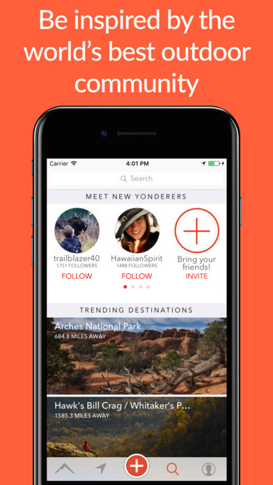

Have you ever wanted a hike chat to share outdoor-related news with those who are interested?
If the answer is yes, then this is your lucky day.
Yonder is a fantastic social network for searching the most appropriate hiking routes. In this app, you can do anything:
- Read reviews
- Watch videos
- Follow cyclists, climbers, and kayakers around the world
- Share your experiences via your account
- Comment on fellow travelers’ posts and find new friends
Unique feature: Update this app for hiking with your stories and experiences, and make lists of your favorite ones.
iOS Free
22. National Parks by Chimani


There are a lot of national park fans among our readers.
The best trail GPS devices can’t show you all the information that National Parks by Chimani can.
This app includes information on 400+ parks, including their history, activities, events, places of interest, news, and more.
The best part?
All of this is available offline!
Unique feature: To motivate you to try new hiking trails, Chimani gives you badges for visiting new national parks.
23. Backpacking Checklist


Searching for the best backpacking apps?
Backpacking Checklist will help you prepare all the items for your trip.
It’s easy to create new lists and use old ones to gather the things you need.
Add new categories and items, hide the items you’ve packed, and edit and delete items. You can also multiply different parts of the list in case you decide to spend 3 days outdoors instead of 1.
Unique feature: Use red, green, and yellow colors to organize your backpacking lists.
iOS $0.99
24. Geocaching


Source: App Store
For those who can’t decide which destination to choose — use Geocaching!
With this unique game, the primary goal is to motivate campers and hikers to spend time outdoors.
In this game, you’re supposed to search for boxes hidden outside. To find them (and win,) you should follow the given instructions.
Isn’t this the best treasure hunt app?
Unique feature: Communicate with other geocachers to get tips and recommendations. Meet up to make the experience even more fun.
25. Plantifier


Interested in plants but not a professional? Download Plantifier.
Here’s the point:
You upload a photo of a flower or plant and then wait for specialists to comment on your image. If you can identify someone else’s picture, help them out by typing the name of the plant.
Unique feature: When someone suggests a name for a plant, you and other users can vote on whether they’re right.
26. Audubon Bird Guide: North America


Downloading free apps for hiking can turn into an unusual hobby.
For example, with Audubon Bird Guide, you can walk in the shoes of an ornithologist — identifying bird sounds, feathers, and behavior.
This is a good app for hiking because of its large database that includes 808 bird species, more than 3,000 high-quality images, and 8 hours of bird sounds.
Unique feature: Save the locations of birds you’ve spotted and make lists of the habitats of local birds.
27. Camp Finder


Source: App Store
Travelers often need a place to stay for a night. But how can you find one easily?
Use this campground finder!
This hiking app for Android and iOS will help you navigate many campgrounds.
You can also leave reviews about the quality of service and read the ones left by others.
Unique feature: With this top camping app, you can sort campgrounds by activities, distance, and amenities; find dog- or kid-friendly places; and search where to use camping club discounts.
iOS $3.99
28. Oh, Ranger! ParkFinder
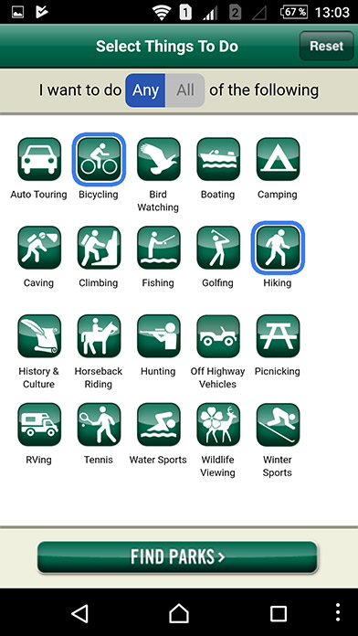


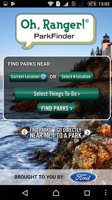
Sometimes, you don’t have time to search through the results of “hikes near me” in Google. Decisions must be made quickly but also well-considered.
In such situations, ParkFinder shines by finding you the best solutions.
It contains information on parks, their directions and coordinates, phone numbers you may need on your journey, places of interest, links to various events, and much more.
Unique feature: ParkFinder has 20 categories so that you can choose the best hiking routes for you or your family. Along with regular activities, you can choose bird watching, horseback riding, or RVing.
iOS Free
So, there you have it — these were the top hiking apps of 2017, presented along with our thorough reviews of their best features. Hike&Cycle carefully chose the most beneficial of these apps and presented them to you in this article. Alternatively, you can check out this fantastic list of apps for true outdoors lovers from SkyAboveUs.
Remember to update your smartphone with some of these useful applications before your next trip.
Of course, we advise you to surf the App Store and the Google Play Store yourself to find the newest apps for hiking. But if you don’t have a lot of time, just leave it to us!
What is your favorite app? Do you use offline maps often? Leave a comment to share your experiences!
Thanks, very helpful
GPS maps are very useful for everyone. Thank you.
Nice Sharing.